1.The Concept of Maritime Communication
Maritime Communications are varied as shown below:
-
i.Emergency and Safety Communications
The Emergency Communication is the communication rendered when an aircraft or vessel becomes embroided in a dangerous situation, while the Safety Communication is the communication rendered when there is a need to prevent navigation accidents.
-
ii.Navigation Assistance Communication
This is a type of radio communication for navigation utilizing the radio wave and estimating the aircraft, vessel position or its direction and distance against a radio wave source point.
-
iii.Telecommunication Work Communication
This is a radio communication used to provide telecommunications with a vessel.
-
iv.Work Communication
This is a self-sustaining radio communication rendered between a coast station on land and a ship station, or between ship stations themselves.
-
v.Harbor Communication
This is a radio communication rendered within or around a harbor in order to control the navigation of any nearby ships, move those ships, and secure their safety as well as human safety in an emergency.
Concept Diagram of Maritime Communications 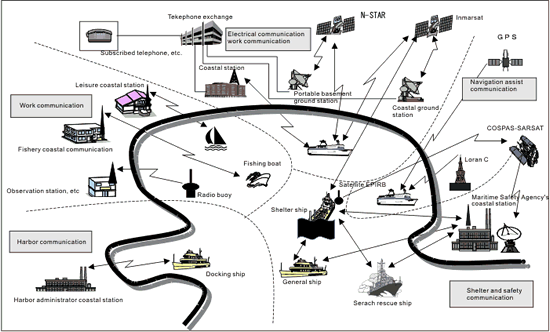
2.Maritime Communication System
-
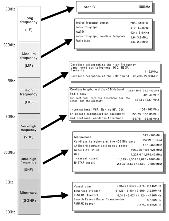
i.Radio Telegraph and Radio Communication of Medium, Intermediate, and High Frequencies
This is the oldest Maritime Communication system. (Radio Telegraph begun between Choshi Coast Station and ships in 1908.)
Distance Range: This depends on the antenna power or whether it is in the day time or late evening, while a possible distance can be about 300 km for the Medium Frequency and about 500 km for the Intermediate Frequency. As for the High Frequency, it's possible to have a distance from several hundred to several thousand kilometers, and by selecting the optimized frequency utilizing ionospheric reflection depending on the season or the time of day, it can realize worldwide communication.
Modes of transmission: 2 cycle single message transmission mode or 1 cycle single message transmission mode.
-
ii.27 MHz Band Wireless Telephone
1WDSB was institutionalized in July, 1955 as the cordless telephone system for small fishing vessels, and SSB was established in November, 1960. After 1965, its popularization spread rapidly with the miniaturization of the equipment and the financial aid of the subsidy, etc. WDSB is, in particular, small-sized and easy to operate, so it spread at the fastest rate as the cordless telephone system for small fishing vessels.
Distance Range: 1WDSB about 50km, SSB about 90km 1 cycle single message transmission mode
-
iii.40MHz Band Cordless Telephone
This was institutionalized in June, 1983 for the coastal fishery and leisure ships with the demand for the wireless communication, leveraging both the wired and wireless communication equipment on the coastal station to connect to the public line, enabling the direct communication between the vessel and the land-based resources such as search and rescue or medical institutions.
Distance Range: about 50km; 1 cycle single message transmission mode or 2 cycle alternate operating mode
-
iv.International VHF
This was institutionalized in September, 1964 and is called "International VHF Cordless Telephone" using "the frequency band between 156MHz and 174MHz" listed in the table of the S18 in RR appendix, and is utilized for some purposes including harbor service communication, electrical communication service, navigation service, and distress safety communication.
Distance Range: about 50km
Depending on the channel, 1 cycle single message transmission mode or 2 cycle alternate operating mode
-
v.Marine VHF
This cordless system was institutionalized in December, 1991 to spread the wireless system to pleasure boats and other types of vessels navigating only in coastal waters, using a part of the frequency of the International VHF, whose wireless equipment is divided into the deferment and portable types.
Marine VHF also enables ship-to-ship communication, communication with leisure-purpose coastal stations, the receipt of navigation alerts and weather information, communication with the Maritime Safety Agency in emergency, and communication with large vessels.
-
vi.400MHz Band Cordless Telephone
This was institutionalized in June, 1986 to spread the wireless system to pleasure boats including motor boats and yachts, and is principally used by the Small Size Safety Association, Inc. (That is why it's sometimes called "Shouankyou.")
This system is especially effective for vessels which have too complicated a body structure to be loaded with the wireless equipment at the 27MHz and 40MHz bands, or vessels whose engine noise is extreme for the 27MHz band.
Distance Range: about 30km; 1 cycle single message transmission mode
-
vii.Marine Community Horn
This was institutionalized in 1988 (official name: Fishery Area Information System) to be used by such small-sized vessels operating in the coastal waters that have too complicated a body structure to be loaded with the wireless equipment or have no power generator a board. Marine Community Horn uses the frequency at 400MHz and adopts the MCA mode, securing the call confidentiality and enabling group calls or general calls in emergencies.
Distance Range: about 30km Qualification of Radio Operator: Not required (Portable Station)
-
viii.Inmarsat Mobile Satellite Communication
The Inmarsat (International Maritime Satellite Organization ) was inaugurated as an international agency in 1979 to ameliorate maritime radio communication, succeeding the marisat system in place in the US since 1982, and has been in operation as a worldwide maritime satellite communication system.
Each of the 4 satellites is distributed over the equator above the Pacific Ocean, the Indian Ocean, and the Atlantic Ocean (east and west), so its service area is targeted as the entire sea area (within the latitude of 70 degrees) except for the polar regions.
One coastal ground station is made to be the Network Coordination Station (NCS) according to the sea area and type out of lots of coastal stations, and completes tasks including the assignment of the frequency for the communication in the appropriate sea area. In Japan, KDDI is providing this service as a party in the operation agreement.
-
ix.N-START Mobile Satellite Communication
This service was initiated in March, 1996 to succeed the service of the coastal cordless telephone ("Ship telephone" which ends its service on March31, 1999) and expand its service area, and complement the service area of the ground system portable telephone.
There are two categories of the fixed type and the portable type of terminals: Single Mode (which connects only to the satellite) and Dual Mode (which is given the priority to connect to the ground system, otherwise connects to the satellite.) The calling covers the Japanese mainland and the sorrounding the mailnland marine area extending approximately 200 nautical miles.
-
x.Shipboard Communication Equipment
This is small-sized portable wireless equipment that deals only with the following kinds of communications (40-3, Chapter 2, Enforcement Regulation):
- communication essential for the ship navigation tasks including ship operation and cargo handling, which is conducted within the vessel body
- communication for rescue activity or rescue training, which is conducted between the vessel and the craft in distress.
- communication for ship-operating assistance, which is conducted between a towboat and the towed ship.
- communication for the berthing and mooring of a vessel, which is conducted between the vessel and the pier, etc.
-
xi.Radio/Buoy
This is a system that targets a buoy with in-built wireless equipment to receive radio waves emitted from there and measure their direction between the ship and other points.
There are the 4 main radio/buoy systems as follows:
- The system that repeats the emission and the pause of the radio wave at all times (general radio/buoy)
- The system which has an in-built timer and repeats the emission and the pause of the radio wave for a specified duration of time initiated from a specified time (radio/buoy with a timer)
- The system which emits the radio wave only when it receives a selection call (sel-call buoy)
- The system which emits the radio wave only when it receives the radar radio wave (radar buoy)
3.Navigation Assist Radio System
There are 18 medium frequency radio beacon stations and 4 Loran C stations, etc. as the navigation assist radio system that unitarily receives the radio wave emitted from the source point on the ground. The Differential GPS has been operated since April, 1999 as a higher-accuracy positioning system.
-
i.Loran C
This is a kind of the ground radio determination system and one of the hyperbola navigation systems that determine the point from the intersection point of the hyperbolas measured by the difference of the pulse wave arriving time.
Loran C is a system evolved from the A mode (1,750kHz - 1,950kHz: already abolished) put into use in US in the 1940s and uses the radio wave of the long frequency band.
The effective distance is between 1,500km (daytime) and 4,000km (night).
The measurement accuracy is between several hundred meters and several thousand meters.
The Loran C in Japanese waters is currently operated under the Maritime Safety Agency and by Korea after it was transferred from the US Coast Guard in July, 1993.
-
ii.Satellite Navigation Equipment (GPS)
This is a system which measures position by receiving the radio wave from the military navigation positioning satellite NAVSTAR developed and managed by the Pentagon.
4 GPSs are placed on each circle orbit with the tilt angle of 55'6" at the altitude of about 20,000km. The total number of these GPSs is 24. GPS has been operated since December 8, 1993 when the Pentagon submitted the declaration about the official operation for public welfare.
This is designed so that more than 4 satellites can be within the visible range all the time and the distance of each satellite can be measured by selecting 4 satellites randomly and receiving the time signal from any point on the earth. As the positions of those 4 satellites can be measured, the time deviation for the user's 3D position and time can be estimated with those parameters.
-
iii.Medium Frequency Radio Beacon
This is a radio beacon targeted at the medium and short distances utilizing the radio wave at the medium frequency band.
It sends the beacon sign and long sound of its own station at a regular time interval and the vessel measures the direction by receiving the corresponding radio wave by the radio direction finder. Finding multiple directions enables the vessel to determine its own position.
Some radio stations transmit sound weather information targeted for the vessel.
-
iv.RAMARK Beacon
This is a radio beacon to send the sequential pulse received by the vessel radar (operation initiated in May, 1969).
The position of the emission station is shown as a dashed bright line from the center towards the station on the vessel radar at 9GHz.
Positioning Distance: about 40km
-
v. Vessel Radar
This is a radio navigation radar in the vessel.
The vessel radar is a pulse mode radar that uses the radio wave of the 3GHz, 5GHz, and 9GHz bands to show the relative position of the other ships or the land coasts by the PPI Display Mode.
- Frequency-specific function
-
- 3GHz band: long-distance use without regard to the weather, but with a low resolution
- 9GHz band: short-distance use with a high resolution
- 5GHz band: intermediate performance between 3GHz and 9GHz, while difficult to maintain
4.Maritime Distress Safety System
GMDSS (Global Maritime Distress and Safety System) is a system in which the alter emitted from the vessel in distress, without regard to the sea area, can be received with centainly by land rescue agencies or nearby ships using digital communication technology or the satellite communication technology, instead of the past Morse communication, enabling the search rescue activity which combines the land-based rescue agencies and the vessel as a rescue unit.
Depending on the navigation area, the vessel scale, and other factors, the following equipment is to be loaded.
| Section | Specific Radio Equipment |
|---|---|
| Communication Equipment by the Medium Frequency, the High Frequency, and the Very-High Frequency | Cordless Telephone, Digital Selection Call Equipment, Narrow Band Direct Printing Equipment |
| Automatic Distress Reporting Equipment | Satellite EPIRB, Search Rescue Radar Transponder |
| Safety Information Receiver | NAVTEX Receiver, Insarmat High-Performance Group Call Receiver |
| Other Equipment | Bidirectional cordless telephone, Bidirectional cordless telephone for the vessel and the aircraft, Digital selection call-specific receiver for the medium, high, and very-high frequencies. |
| General Communication Equipment | Inmarsat Vessel Earth Station, N-STAR Satellite Vessel Telephone, etc. |